
Introduction to Orbis3D
What Orbis3D does, who it is for, how it relates to Orbis, and a first look at real Himalayan terrain in 3D.
You will learn
- What Orbis3D is for and what it can do.
- How Orbis3D handles your data.
- Where to go next in the tutorials.
Prerequisites
None. This is a good place to start.
Data for this tutorial
Nanda Devi massif, SRTM (real terrain) Download nanda-devi-srtm-1arcsec.tif
- Format
- GeoTIFF, 1 band, Int16, Deflate, tiled
- CRS
- EPSG:4326 (WGS 84, longitude/latitude)
- Content
- Elevations 2285 to 7801 m above the EGM96 geoid; lon 79.7276 to 79.9776, lat 30.2279 to 30.4779
- In Orbis3D
- Data panel ▸ Sample data ▸ Nanda Devi massif, SRTM (real terrain) ▸ Load
- Licence
- SRTM 1 arc-second, NASA/USGS, public domain
Synthetic samples are CC0 1.0; the SRTM sample is public domain. About the datasets
The task
Orbis3D is a 3D terrain viewer and analysis tool that runs in your web browser. You give it a digital elevation model (DEM), a raster in which every cell holds a ground height, and it builds an interactive 3D surface that you can turn, light, colour, measure and export. It is a sibling of Orbis, the browser GIS, and uses the same interface style. Where Orbis works with maps of vector and raster layers, Orbis3D concentrates on terrain.
In this tutorial you open a real elevation model of the Nanda Devi massif in the Garhwal Himalaya and look at what Orbis3D shows you.
Steps
- Open Orbis3D. The 3D viewport in the middle of the window is empty and invites you to open an elevation model.
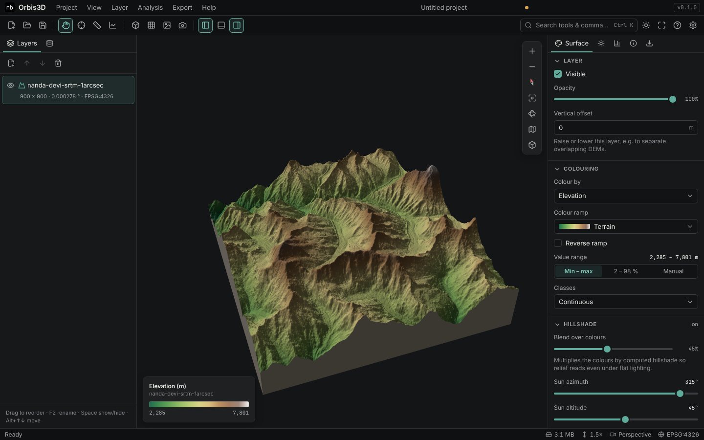
- Click Try Nanda Devi (SRTM). The sample is fetched from this website and opened like a file from your computer. After a moment a coarse preview appears, then the full 900 × 900 cell terrain.
- Drag in the viewport to turn the terrain, and scroll to zoom. The legend at the bottom left gives the elevation colours: 2,285 m in the valleys to 7,801 m on the summit ridge.
What Orbis3D can do
| Area | What you can do |
|---|---|
| Open data | GeoTIFF and Cloud Optimized GeoTIFF, ESRI ASCII Grid, SRTM .hgt tiles, ZIP archives of these |
| 3D view | Perspective and orthographic cameras, presets, vertical exaggeration, lighting and shadows, wireframe |
| Colour | Elevation colour ramps, classes, custom colours, slope, aspect, hillshade, draped images |
| Analysis | Slope, aspect, hillshade, contour lines, elevation profiles, distances, point inspection, statistics, the difference between two DEMs |
| Export | GLB/glTF and OBJ models, PNG images, CSV tables, GeoTIFF and ASCII Grid rasters, GeoJSON contours |
| Projects | Save in the browser, project packages (.zip), project files (.json) |
How your data is handled
Orbis3D is a static website. When you open a file, your browser reads it and processes it in background workers on your own computer. Nothing is uploaded, and there is no account. Read more in Privacy and local processing.
Expected result
The Nanda Devi terrain is shown as a coloured 3D block with steep, shaded ridges and deep valleys. The status bar reads Ready and shows the coordinate system of the layer, EPSG:4326.
Where to go next
- Using Orbis3D directly in your browser: requirements and offline use.
- Understanding the interface: a tour of the window.
- Importing your first DEM: open your own data.