
Understanding coordinate systems and units
Geographic and projected coordinates, horizontal and vertical units, how Orbis3D reads and assumes them, and how to correct them.
You will learn
- Tell geographic and projected coordinate systems apart.
- See how units affect 3D shape, slope and distances.
- Correct an unknown or wrong coordinate system.
Prerequisites
Data for this tutorial
Sample valley, ASCII Grid (synthetic) Download orbis3d-sample-valley-60m.asc Download orbis3d-sample-valley-60m.prj
- Format
- ESRI ASCII Grid (.asc) with .prj
- CRS
- EPSG:32643 (WGS 84 / UTM zone 43N)
- Content
- 240 × 180 cells of 60 m; NODATA_value -9999
- In Orbis3D
- Download it, then open it with Project ▸ Open files
- Licence
- Synthetic, CC0 1.0
Synthetic samples are CC0 1.0; the SRTM sample is public domain. About the datasets
Why it matters
A DEM's cells are only meaningful with their size. Orbis3D needs to know how large a cell is on the ground and in which unit the heights are, to build a terrain with the right proportions and to compute slope, distances and profiles. Getting the units wrong makes mountains look like needles or pancakes and slopes wrong by large factors.
Geographic and projected
| Geographic | Projected | |
|---|---|---|
| Coordinates | Longitude and latitude in degrees | Easting and northing in metres (or feet) |
| Example | EPSG:4326 (WGS 84), SRTM tiles | EPSG:32643 (WGS 84 / UTM zone 43N) |
| Cell size | Fixed in degrees, variable on the ground | Fixed on the ground |
A degree of longitude shrinks towards the poles: 111 km at the equator, 96 km at 30° N, 56 km at 60° N. Orbis3D therefore never treats degrees as metres:
- the 3D terrain converts degrees to metres on the WGS 84 ellipsoid at the centre of the first layer;
- slope, aspect and hillshade use the ground size of the cells at the latitude of each row;
- distances are geodesic on the ellipsoid.
Web Mercator (EPSG:3857) is projected but its metres are only true at the equator; Orbis3D corrects for this with the cosine of the latitude.
Where Orbis3D reads the coordinate system
- GeoTIFF GeoKeys (EPSG code, linear unit, vertical unit).
- A .prj file next to the DEM (WKT, also ESRI style).
- The SRTM convention for
.hgtfiles (WGS 84, metres).
If none is available, Orbis3D guesses carefully and tells you: coordinates that fit within ±180° and ±90° with small cells are treated as geographic degrees; anything else as metres. A yellow Check the units note then appears in Info ▸ Units and scale, and the status bar shows CRS unknown in orange.
Steps: correct the units of an ASCII Grid
- Download the ASCII Grid sample but drop only the
.ascfile. - Open Info ▸ Units and scale. The note says no
.prjwas provided.
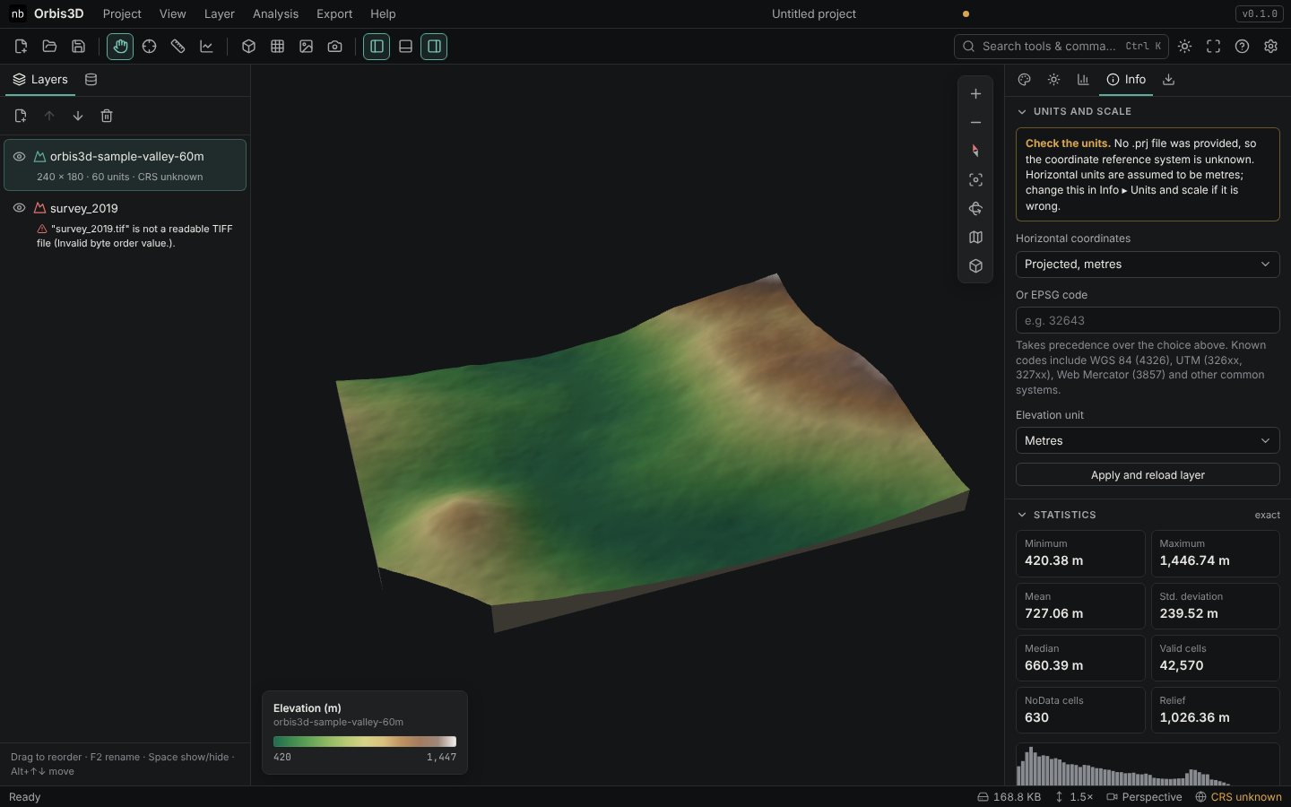
- In Or EPSG code, type
32643, or choose Horizontal coordinates ▸ Projected, metres. - Check Elevation unit (metres here).
- Click Apply and reload layer. The layer now shows EPSG:32643, and latitude and longitude appear in the Inspect card.
Better still: drop the .asc and .prj together, so the file describes itself.
Feet
- International feet (0.3048 m) and US survey feet (1200/3937 m) are read from the GeoKeys or
.prjand converted. - Elevations in feet: set Elevation unit to feet. Slopes, profiles and the 3D heights are then correct.
Latitude and longitude from projected DEMs
Orbis3D converts to latitude and longitude for UTM zones on WGS 84, NAD83 and ETRS89, and for Web Mercator. For other projected systems the Inspect card shows the native coordinates only, and contour GeoJSON keeps native coordinates with the CRS named in the file.
Combining layers
Layers are placed together only when their coordinate systems are the same. Reproject with GDAL first, for example gdalwarp -t_srs EPSG:32643 input.tif output.tif.
Common mistakes
- Ignoring the yellow note. Wrong units silently scale every result.
- Mixing vertical datums. Ellipsoidal and geoid heights differ by tens of metres; Orbis3D cannot detect it.